

In many smaller vineyards around the world most of the management practices such as planting, weeding, spraying, and picking are all very traditional, and carried out by hand with the help of some small mechanical equipment such as rotavators and small-scale tractors. However, in some of the larger vineyards these practices may be far more reliant on large tractors and mechanised equipment such as ploughs and sprayers. Even in the more extensive commercial vineyards – a good example often cited are those of Robert Mondavi in California – many of the day to day tasks will be carried out with the aid of mechanical equipment that not only prunes and sprays the vines but also picks the grapes, often guided by location-based technology e.g. Global Positioning Systems (GPS). Some vineyards even use aerial photographs taken at regular intervals to regularly assess the status of the vines in the vineyard. The value of using this, often very costly practise, is the economic benefit it brings to a commercial enterprise worth many millions of dollars each year. This is where modern technology can help in growing the best grapes and why 'precision viticulture' (PV) has been developed.
Whilst such sophisticated mechanisation is still largely the province of the really big commercial vineyards, some of this equipment and technology is now gradually becoming more commonplace in smaller vineyards around the world thanks to cheaper micro-processor technology. PV is the use of spatial (geography and location) and related technologies for the study of geographical variability in the vineyard as the means to provide a more objective basis for management practices. Whilst PV is most often associated with the vineyards in the USA, Australia, and Canada, in recent years precision viticulture has begun to find its way into most wine growing countries including Spain, Slovenia and New Zealand, and even the UK.
What is Precision Viticulture?
There are a number of different technologies and applications that come under the heading of PV. Today, most people are quite familiar with Global Positioning Systems (GPS) - whether as a navigational and locational aid when hill walking, in the car, or on a boat. But GPS can, for example, be used to help navigate tractors around a vineyard guided by a GPS unit located in the driver’s cab. GPS controlled equipment is also used to position the posts supporting the vine trellis, as well as vine plants during the planting of a vineyard, providing centimetre accuracy in the positioning and spacing of the plants and rows. In addition, GPS-guided equipment is used to help deliver doses of fertiliser, pesticides and herbicides exactly where they are needed in the vineyard as well as to prune vines and pick grapes. Though still not cheap yet this technology is now sufficiently well developed to carry out many of the more traditional time consuming and backbreaking tasks in planting and managing a vineyard.
Besides using GPS units to control vineyard management equipment, they also form the basis of mapping any features of a vineyard e.g. fences and tree shelter lines, as well as buildings, and the most recent GPS units - coupled with graphic or mapping software - provide the means to map a vineyard in its entirety. More expensive units allow the vineyard manager to quickly generate a detailed map of any vineyard requiring minimal knowledge and expertise.
Naturally, more sophisticated solutions are also rapidly becoming available. Maps collected in the field can be input into desktop software called Geographical Information Systems (GIS). GIS provide a toolbox to input, manage and visualise or display both map and image data. Today there are many opensource (free) examples of GIS software such as uDig and MapWindow that can be downloaded from the Internet. This free source of software is more than adequate to help a vineyard start using GIS. Such tools provide a quicker and easier way to generate an accurate map that can easily be edited and added to over time. Acquiring a GIS can provide the vineyard manager with an efficient way to manage the vineyard as well as generate informative graphics that can all be easily updated. Vineyard maps can easily be created in GIS software, usually with the aid of an aerial photograph as a backdrop 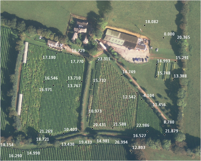 and can be designed and output in a variety of different forms for different uses. With wine tourism becoming more important, having an accurate, detailed and professional looking map for display in the vineyard, or on vineyard flyers, and on the vineyard website is becoming more and more important.
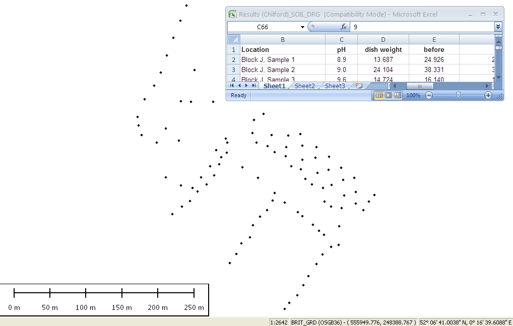
For the more ambitious vineyard manager, GIS also provides the means to create a vineyard database which can be used to store information, not only about what vine varieties are located where in the vineyard, but also information about the vine condition, the date of planting, as well as other useful information such as soil type and soil characteristics, the local geology, and information about grape yield amongst many other things - the possibilities are almost endless. Such databases can be created in the GIS software or in a common desktop application such as MS-Office’s Access.
Another interesting development in vineyard management is use of the freely available Google Earth (GE) software and the Internet. Most people by now are familiar with Google Earth, and both map and image data can easily be converted for display in this software, with the possibility to add further information to the view and the possibility of generating fly-throughs or virtual fieldtrips; something that can be an interesting addition to the vineyard website. Amongst other things GE can be used as a simple GIS, and information can easily be added in the form of layers to overlay the GE imagery to create simple visualisations of the vineyard terrain. Most GIS software now also allows the creation and export of GE files - known as KML (Key Markup Language) files - to GE.
Remotely sensed data in the form of aerial photographs and satellite images have been widely used for many years to provide up-to-date information about vineyards including soils, soil moisture and grapevine condition. The acquisition of low-cost photographic and digital imagery is now also possible with model aircraft and helicopters, as well as other larger UAV (unmanned airborne vehicles)  something which enables the vineyard manager to obtain imagery virtually on demand. Besides colour aerial photographs, Colour InfraRed (CIR) imagery has become more widely available and can reveal useful information about vine health. Satellite imagery is used to derive information about the vine plant in the form of the Normal Vegetation Difference Index (NDVI). This requires the use of digital image processing (DIP) software; similar to graphics software used by photographers to edit photographs from digital cameras, DIP software can be used to extract information such as biomass and yield all useful to the vineyard manager. DIP software is also available for free on the Internet e.g. TNT Lite and can be used almost in a plug and play mode to extract information on a repetitive basis.
Besides the acquisition of data and information at the scale of the vineyard, PV also covers the acquisition of large scale data. For example, many vineyard managers require information about the microclimate of a vineyard. Useful measurements include minimum (MIN) and maximum (MAX) temperatures, light intensity, wind speed, and relative humidity (RH). Such measurements are helpful for optimising the management of the grape crop during the growing season. Today meteorological sensors 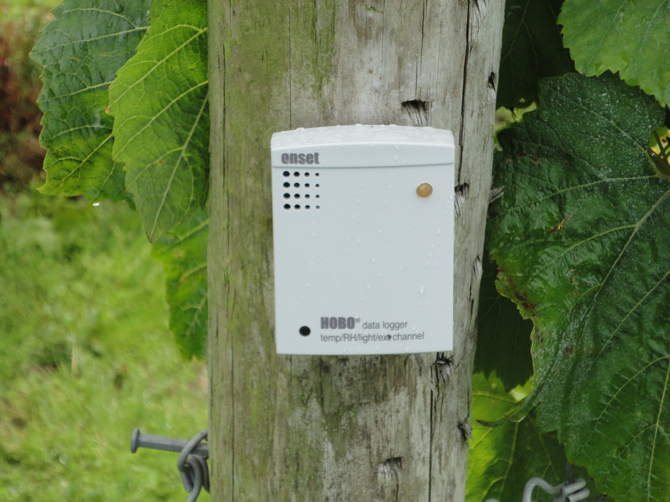 are smaller, cheaper and can be operated in an automated mode, allowing data collection in multiple locations in the vineyard which can either be plugged into a computer using a USB cable or by taking advantage of wireless networks to relay information to a single computer in the manager’s office. Many of these devices are now quite compact and come with software that configures the sensor, uploads the files, and displays the data in the form of a graph for ease of interpretation
 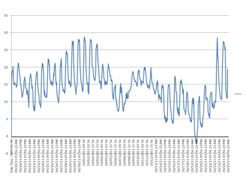 . When associated with a GPS location such measurements can be useful for examining and monitoring the variability of many different aspects of the vineyard microclimate which in turn can be correlated with the slope and topography of the vineyard site. Knowledge about the slope and aspect of a vineyard can be important for studying soil moisture and drainage, as well as cold air drainage; the effects of physical barriers e.g. tree shelterbelts and terracing, and channels e.g. ditches on cold air pooling and potential frost pockets, as well as maximising exposure to the sun for ripening the grapes. Site contours and 3-Dimensional terrain surfaces can be acquired from mapping agencies, or derived from aerial photographs using techniques known as photogrammetry. More recently, remotely sensed data such as LIDAR can provide detailed digital terrain models (DTMs) of a vineyard site as well as digital surface models (DSMs) showing the structures on the land surface.
Most GIS have visualisation tools to display spatial information in the form of traditional looking maps or as 3-Dimensional terrain models which provide a feel for the topography of the site. Additional layers of information can easily be overlain on top of the topography which helps to provide insight into the relationships between the vines and the soils, soil moisture, air drainage, and exposure to the sun. As visualisation tools have become more powerful, realistic views of the vineyard can easily be displayed on a desktop or laptop computer, whether PC or Apple (including iPads) and used for further study or simply for a variety of communication purposes.
With the capability to acquire and display a wide range of data collected in the vineyard, more advanced uses of such information include the development of simulation models which allow one to create computer-based models of the vine plant and canopy. These can help to develop greater insight into growth and canopy development as well the sun, canopy, sun-shade relationships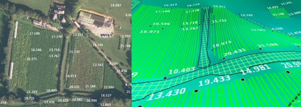 .
.
PV - A Grape Future
Although not yet used by all vineyards and vineyard managers around the World, possibly still hindered by the potentially prohibitive costs, lack of expertise, and the scale of operation, precision viticulture clearly offers many benefits which can aid in many aspects of vineyard management from planting the vines to growing the grapes. The acquisition of greater knowledge and understanding about the vineyard is clearly important if it leads to better grape yields, and ultimately a better harvest. There are also many other benefits, not least that the vineyard manager has a better and more complete record of information for the vineyard, one that can be updated, mapped and studied, providing the basis for a decision support system (DSS) to help make more informed decisions. Ultimately PV can only lead to better information, and an improved knowledge and understanding of the vineyard, and the production of grapes and wine.
Yes - it is true that that vineyards have been managed without such technology in the past, and many vineyards will continue to do so in the future, but rather than replacing traditional approaches, such technology should be viewed as being complementary, adding many new opportunities which can only lead to better grapes and benefit fine wine production.
In many smaller vineyards around the world most of the management practices such as planting, weeding, spraying, and picking are all very traditional, and carried out by hand with the help of some small mechanical equipment such as rotavators and small-scale tractors. However, in some of the larger vineyards these practices may be far more reliant on large tractors and mechanised equipment such as ploughs and sprayers. Even in the more extensive commercial vineyards – a good example often cited are those of Robert Mondavi in California – many of the day to day tasks will be carried out with the aid of mechanical equipment that not only prunes and sprays the vines but also picks the grapes, often guided by location-based technology e.g. Global Positioning Systems (GPS). Some vineyards even use aerial photographs taken at regular intervals to regularly assess the status of the vines in the vineyard. The value of using this, often very costly practise, is the economic benefit it brings to a commercial enterprise worth many millions of dollars each year. This is where modern technology can help in growing the best grapes and why 'precision viticulture' (PV) has been developed.
Whilst such sophisticated mechanisation is still largely the province of the really big commercial vineyards, some of this equipment and technology is now gradually becoming more commonplace in smaller vineyards around the world thanks to cheaper micro-processor technology. PV is the use of spatial (geography and location) and related technologies for the study of geographical variability in the vineyard as the means to provide a more objective basis for management practices. Whilst PV is most often associated with the vineyards in the USA, Australia, and Canada, in recent years precision viticulture has begun to find its way into most wine growing countries including Spain, Slovenia and New Zealand, and even the UK.
What is Precision Viticulture?
There are a number of different technologies and applications that come under the heading of PV. Today, most people are quite familiar with Global Positioning Systems (GPS) - whether as a navigational and locational aid when hill walking, in the car, or on a boat. But GPS can, for example, be used to help navigate tractors around a vineyard guided by a GPS unit located in the driver’s cab. GPS controlled equipment is also used to position the posts supporting the vine trellis, as well as vine plants during the planting of a vineyard, providing centimetre accuracy in the positioning and spacing of the plants and rows. In addition, GPS-guided equipment is used to help deliver doses of fertiliser, pesticides and herbicides exactly where they are needed in the vineyard as well as to prune vines and pick grapes. Though still not cheap yet this technology is now sufficiently well developed to carry out many of the more traditional time consuming and backbreaking tasks in planting and managing a vineyard.
.../continued...you need to upgrade your subscription if you wish to read this content.
In many smaller vineyards around the world most of the management practices such as planting, weeding, spraying, and picking are all very traditional, and carried out by hand with the help of some small mechanical equipment such as rotavators and small-scale tractors. However, in some of the larger vineyards these practices may be far more reliant on large tractors and mechanised equipment such as ploughs and sprayers. Even in the more extensive commercial vineyards – a good example often cited are those of Robert Mondavi in California – many of the day to day tasks will be carried out with the aid of mechanical equipment that not only prunes and sprays the vines but also picks the grapes, often guided by location-based technology e.g. Global Positioning Systems (GPS). Some vineyards even use aerial photographs taken at regular intervals to regularly assess the status of the vines in the vineyard. The value of using this, often very costly practise, is the economic benefit it brings to a commercial enterprise worth many millions of dollars each year. This is where modern technology can help in growing the best grapes and why 'precision viticulture' (PV) has been developed.
Whilst such sophisticated mechanisation is still largely the province of the really big commercial vineyards, some of this equipment and technology is now gradually becoming more commonplace in smaller vineyards around the world thanks to cheaper micro-processor technology. PV is the use of spatial (geography and location) and related technologies for the study of geographical variability in the vineyard as the means to provide a more objective basis for management practices. Whilst PV is most often associated with the vineyards in the USA, Australia, and Canada, in recent years precision viticulture has begun to find its way into most wine growing countries including Spain, Slovenia and New Zealand, and even the UK.
What is Precision Viticulture?
There are a number of different technologies and applications that come under the heading of PV. Today, most people are quite familiar with Global Positioning Systems (GPS) - whether as a navigational and locational aid when hill walking, in the car, or on a boat. But GPS can, for example, be used to help navigate tractors around a vineyard guided by a GPS unit located in the driver’s cab. GPS controlled equipment is also used to position the posts supporting the vine trellis, as well as vine plants during the planting of a vineyard, providing centimetre accuracy in the positioning and spacing of the plants and rows. In addition, GPS-guided equipment is used to help deliver doses of fertiliser, pesticides and herbicides exactly where they are needed in the vineyard as well as to prune vines and pick grapes. Though still not cheap yet this technology is now sufficiently well developed to carry out many of the more traditional time consuming and backbreaking tasks in planting and managing a vineyard.
.../continued...you need to subscribe to be able to view content from Fine Wine magazine.
Subscribe HERE to Fine Wine magazine to read the rest of this content or log yourself in if you are already a member.


